
By Husam Sobhi | For Humat Dijlah
Brief Overview:
In Iraq today, where the water crisis intersects with the challenges of climate change, environmental observation is becoming more than just data; it is the compass that guides policies and protects resources. This article explores how physical and chemical observation, remote sensing technologies, open-source tools, and community-based initiatives can provide an accurate water map, enabling decision-makers to address drought and manage water demand sustainably. In short, environmental observation is key to understanding the water reality and building a water-conscious and resilient future in Iraq.
__________________________________________________________________
In recent years, Iraq has faced a rapid escalation of water-related challenges, driven by a combination of factors ranging from the impacts of contemporary climate change and reduced water inflows from upstream countries to shortcomings in internal water management and unsustainable consumption. What were once considered environmental or sectoral concerns have now evolved into a genuine threat to the country’s water security, economy, and social stability. Within this context, environmental observational systems emerge as a vital strategic tool for analyzing and understanding the water situation. Integrating environmental monitoring data into decision-making processes is a crucial step toward shaping more effective, sustainable, and adaptive water policies that address the needs of both present and future generations.
The Conceptual Framework for Environmental Observation: A Tool for Understanding Change and Policymaking
What cannot be measured cannot be managed. This underscores the importance of environmental observation as a vital tool for environmental policy and its associated analytical instruments. Environmental observation serves as a fundamental pillar for understanding changes in ecosystems and climate, providing the essential data and information upon which scientific analyses and public policies are built. Environmental observation is defined as a set of systematic processes designed to collect and analyze data on natural resources, particularly water, with regard to their quantity, quality, and distribution. The importance of environmental observation lies in providing a continuously updated, on-the-ground picture of the state of water resources. It enables a broader understanding and facilitates the early detection of adverse changes, such as declining river levels and receding riverbeds, shrinking reserves in lakes and dams, rising salinity, or increasing rates of pollution and fires. For Iraq, which depends heavily on external water sources and faces growing threats to its water security, such observation provides the scientific foundation for any sound policy or sustainable national plan.
Classifying environmental observation methods: How does their diversity provide clearer insights for informed policy formulation?
Farmers do not rely solely on soil color to assess its fertility; they also examine moisture levels, salinity, and its impact on crop growth. Similarly, the observation of water resources cannot depend on a single indicator or tool. Water is more than numbers on river levels or storage capacity, it is an interconnected system where quantity intersects with quality, and present conditions must be considered alongside future changes. The need lies in employing a diversity of environmental observation methods to develop a comprehensive picture that provides decision-makers with an accurate and objective understanding of the water situation. Observation methods are not limited to those discussed here; other models exist for soil, air, biodiversity, and more. However, this brief article focuses on five fundamental categories that are particularly important for water resource management in Iraq, given their direct relevance to water quantity and quality, and their ability to track natural and human-induced changes affecting it.
Physical observation can be considered the simplest and most direct form of environmental observation. It begins with basic observations of river levels or water quantity and progresses to precise scientific measurements using flow meters and hydrological stations. Its core purpose is to answer the question: How much water do we have, and where does it flow?
In Iraq, physical observation provides essential data on the Tigris and Euphrates rivers and major dams, such as Mosul and Haditha, enabling the tracking of water flow and distribution. Over the long term, accumulated data allows physical observation to serve as a tool for predicting droughts and floods and for supporting sustainable water resource management.
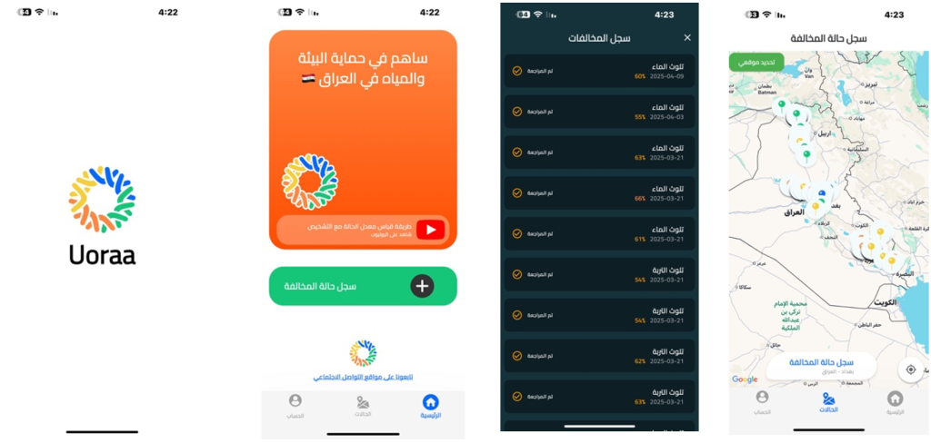
One of the world’s most successful examples is the U.S. Geological Survey’s (USGS) physical observation network, which includes more than 8,000 measuring stations along rivers, lakes, and springs. These stations continuously record flow, water levels, and temperature, and provide live data online. This network enables the prediction of floods and droughts, delivers real-time information, and fundamentally supports water allocation decisions. On a local scale, we have the Uoraa app, developed by the Humat Dijlah Association, as an innovative attempt at physical water monitoring in Iraq. The app enables citizens to take an active role in protecting water resources through immediate notification and reporting of river encroachments and waste dumping, documenting them with photos and geographic locations. This initiative fosters the integration of technology and civil society to generate accurate data that supports river and water resource observation.
Just as physical observation answers the question, “How much water do we have and where does it flow?”, chemical observation goes further to address the more critical question: “What is the quality of this water, and is it suitable for human and agricultural use?” Chemical observation thus becomes an essential tool, complementing the picture provided by physical observation.
In Iraq, where the challenge extends beyond water scarcity to include contamination by salinity and pollutants from industrial and agricultural activities, chemical observation is no less essential than the measurement of water levels and flows. The problem lies not only in the decline of the Tigris and Euphrates waters but also in their changing quality and characteristics, which have increasingly limited their ability to meet the needs of both people and crops. A stark example is the Shatt al-Arab crisis, where rising salinity and pollution have rendered thousands of hectares of agricultural land unusable, threatening livelihoods and food security in the region. France’s experience in rehabilitating the River Seine illustrates the necessity and impact of chemical observation as a tool for transformation. In the 1960s, the river was heavily polluted and almost entirely devoid of biological life. Through systematic observation of chemical indicators such as dissolved oxygen and industrial pollutants, the scale of the crisis was revealed, guiding policies toward water treatment and strict environmental legislation. Over time, as data accumulated and informed decision-making, the Seine gradually regained its ecological balance. Dozens of fish species returned, and by 2024 the river had become suitable for swimming, even serving as a venue during the Paris Olympics.
With the growing need for accurate and reliable water data, physical and chemical observation alone is no longer sufficient to provide a complete picture. At this stage, observation using open tools and sources becomes essential, representing a paradigm shift in the way water information is generated, accessed, and utilized. Instead of data being confined to institutions, it is now made available in an open space accessible to all—ordinary people, organizations, local communities, academics, universities, and research centers alike. The power of open observation lies in transforming information from an elite tool into a shared resource. What was once the exclusive domain of state agencies or specialized laboratories is now accessible through digital platforms that offer a clearer view of the global water landscape. Numerous websites provide open-source data that accurately track changes in water bodies and their quality.
This approach has enabled several countries to predict droughts and monitor pollution before it worsens. In parallel, the Global Water Watch project provides real-time estimates of reservoir, river, and lake levels through remote sensing and artificial intelligence technologies, with results made accessible to researchers and communities. Locally, the Uoraa app, developed by Humat Dijlah Association, offers a promising model for open community observation in Iraq. It allows citizens to directly report environmental violations, such as waste dumping in rivers or encroachments on water resources, while documenting them with photos and geolocation. These tools empower communities to move from being passive recipients of crises and problems to becoming active participants in observation and solution development. Despite its simplicity, this initiative represents a cornerstone for adopting the concept of open knowledge and linking it to sustainable water governance.
Remote sensing is a central tool for understanding water systems. Satellites and drones enable near-real-time observation of water bodies on a large scale. Through this technology, it becomes possible to track the decline of marshlands, monitor the spread of salinity in the Shatt al-Arab, and even estimate the volume of water stored in dams without requiring a permanent presence in the field. This represents a qualitative leap that transforms the sky into a “third eye,” complementing the limitations of traditional observation tools and opening unprecedented horizons for sustainable water governance.
Any observation effort remains in its infancy unless it is supported by high accuracy and continuity. Information that is inaccurately measured or whose recording chain is interrupted can mislead more than it informs. Because water management in Iraq relies on sensitive decisions influenced by daily and seasonal changes, the sustainability of observation and the assurance of its credibility become prerequisites for transforming data into knowledge, and knowledge into policy. This completes the conceptual framework for environmental observation.
Any observation effort remains in its infancy unless it is supported by high accuracy and continuity. Information that is inaccurately measured or whose recording chain is disrupted can mislead more than it informs. Since water management in Iraq relies on sensitive decisions influenced by daily and seasonal variations, sustaining observation and ensuring its credibility are prerequisites for transforming data into knowledge, and knowledge into policy. This completes the conceptual framework for environmental observation.
Who is mapping Iraq’s water observation? A quick look at the current monitoring landscape
A seemingly simple question, yet a closer look reveals a complex network of actors and stakeholders. Iraq’s current water observation is not the responsibility of a single institution; rather, it relies on multiple actors, each with their own focus. The Ministry of Water Resources leads by managing stations that measure water levels and flows and by monitoring dams and reservoirs. The Ministry of Environment observes water quality and pollution levels, while the Ministry of Health oversees drinking water standards. At the academic level, universities and research centers conduct field surveys and laboratory analyses, and international organizations such as UNESCO and the United Nations Development Programme (UNDP) contribute to capacity development and provide modern observation systems. A 2024 UNDP study indicates that Iraq’s capabilities in drought monitoring and early warning remain limited. Meteorological observation infrastructure is deficient, scientific knowledge and service delivery skills are insufficient, and modern tools that transform data into effective early warnings are lacking. Although Iraq’s water observation landscape is divided among ministries, agencies, universities, and organizations, this division has yet to coalesce into an interconnected network capable of producing reliable information to guide water policies. The lack of coordination is like having many strings without a tune. What is needed is a fully integrated orchestra that can play a clear tune, reflecting the water reality and guiding decisions toward proactive and rational management.
From Observation to Decision
After discussing environmental observation and its various types which contribute to tracking water resources through physical, chemical, and modern technical approaches, another fundamental question arises: How can this precise data be transformed into tangible decisions and policies? Environmental observation, no matter how accurate, remains merely unless it is translated into a practical vision that helps rationalize consumption, monitor and protect water from pollution, and enhance society’s capacity to confront the water crisis.
The Room for the River experiment in the Netherlands provides a vivid example of this connection. Precise observation data on river flow and water levels was used to formulate a national policy for redesigning the banks of the Rhine River and its tributaries. Rather than relying on traditional solutions, such as higher dams and stronger barriers, the strategy focused on widening river channels and giving them more natural space to accommodate floods. This experiment transformed environmental observation from a mere measuring tool into the foundation for innovative preventative policies, offering Iraq an opportunity to leverage observation data to rethink more sustainable approaches to water management.
Scientific experiments also show that digitization and remote sensing offer effective solutions to the shortage of field equipment. This aligns with recent Iraqi initiatives, such as the UNDP-supported Water Digitization and Observation Project 2023, which seeks to introduce digital analysis technologies to the Tigris and Euphrates rivers. Thus, international models should not be viewed as ready-made prescriptions, but as flexible frameworks from which Iraq can draw inspiration such as adopting open-source systems to reduce operational costs and directly integrating scientific observation into water decision-making, transforming data into concrete policies.
Prospects for Environmental Observation in Iraq
After exploring the details of environmental observation, its types and its role in reshaping water resource management, the question arises: what is the realistic future of this practice in Iraq? Despite its evident clarity and importance, the country faces a fragile reality in this field, marked by limited institutional interest, inadequate funding, and weak coordination between ministries and research centers. Yet, the opportunity for meaningful change remains, provided the state adopts a clear strategic vision and harnesses modern technologies to collect and analyze data.
In this context, Khadija Al-Jaberi, a climate change and water resources expert, emphasizes that “environmental observation in Iraq is not a scientific luxury, but rather a vital necessity to ensure water sustainability over the next five years. If the water crisis continues at its current pace without accurate and sustainable data, the ability to make wise decisions will remain limited. Continuous and accurate observation can provide a clear roadmap for preserving water resources and protecting Iraq from future shocks.”
The prospects for environmental observation in Iraq remain tied to the state’s adoption of this vision, along with technological innovation and local research initiatives. Even with the current challenges, remote sensing technologies, drones, and open-source platforms offer the potential to build a smart, scalable observation network, enabling Iraq to develop strategies based on accurate and realistic data and better guide water policies.
Final Word: Environmental Observation as a Gateway to Sustainable Water Governance
Today, observation is an integral part of the dynamics of successful countries. Environmental water observation is no longer merely a technical or routine activity; it has become a fundamental entry point for building sustainable water governance. It empowers decision-makers to shift from improvisation to sound planning and implementation, and from reactive to proactive policies. Achieving this, however, requires clear political will and long-term investment. Sustainable water governance cannot be established without allocating sufficient financial and human resources, and without recognizing that observation and its mechanisms are not a burden on the budget, but an investment in the future of water, as well as economic and social security.
Hence the call to establish a unified national water environmental observation system, one that would provide a comprehensive framework for ministries, universities, and organizations, supported by sustainable funding and open data exchange. Adopting such a system could serve as a “national water memory,” preserving knowledge, guiding policies, and enabling Iraq to plan for a more stable and equitable water future.
Reference:
- UNEP – https://wedocs.unep.org/handle/20.500.11822/12207?utm_source
- DAHITI Database – https://dahiti.dgfi.tum.de/en/map/
- Global Water Watch – https://www.globalwaterwatch.earth/about/?utm_source
- USGS Publication – https://pubs.usgs.gov/publication/gip242?utm_source
- USGS Hydro geophysical Studies – https://www.usgs.gov/mission-areas/water-
resources/science/integration-suas-hydrogeophysical-studies?utm_source - UNDP Iraq – https://www.undp.org/iraq/stories/undp-supports-iraqs-water-
sector?utm_source - Wired (Seine cleanup) – https://www.wired.com/story/no-the-seine-cleanup-wasnt-
a-failure/?utm_source - ESA(PoRiver)
– https://www.esa.int/Applications/Observing_the_Earth/Italy_s_Po_River_seen_thinni
ng_from_orbit?utm_source - Springer Journal – https://link.springer.com/journal/11269
- UNESCO IHP – https://www.unesco.org/en/ihp?utm_source
- IWA Water Health – https://iwaponline.com/jwh/article/22/7/1162/102995/The-
application-of-satellite-sensors-current-state - SpringerBook– https://link.springer.com/book/10.1007/978-3-319-32449-
4?utm_source - PlanetarySecurityInitiative
– https://www.planetarysecurityinitiative.org/news/dialogue-solution-save-
fisheries-saltwater-intrusion-southern-iraq?utm_source - JHU Press (Book) – https://muse.jhu.edu/book/81913/?utm_source
- Room for the River (Netherlands)
– https://www.rijkswaterstaat.nl/en/projects/iconic-structures/room-for-the-river - UN Water Development Report – https://www.unwater.org/publications/un-world-
water-development-report-2021?utm_source - Copernicus – https://www.copernicus.eu/en
- NGIS (Murray-Darling Basin) – https://ngis.com.au/case-studies/murray-darling-
basin/?utm_source - EEA Glossary – https://www.eea.europa.eu/help/glossary/gemet-environmental-
thesaurus/environmental-monitoring?utm_source - Uoraa App – https://apps.apple.com/iq/app/uoraa/id6738790857
- UNDP Report 2024 – https://www.undp.org/sites/g/files/zskgke326/files/2024-
06/institutional_survey_assessment_report_on_drought_early_warning_system_in_iraq
.pdf?utm_source - UNCCD (Spain’s Drought Monitoring Tool) – https://www.unccd.int/news-
stories/stories/spains-drought-monitoring-tool-advance-global-resilience-through-
idra?utm_source - US EPA Climate Change – https://www.epa.gov/climatechange-science/causes-
climate-change?utm_source - Khadija Aljabry,Climate and Agriculture,Expert:
https://www.linkedin.com/in/khadija-al-jabiry-3bb00827/


Leave a Reply